75 years after World War Two ended and Britain lets its WW2 heritage fall into ruins.

Pill box by Garston Docks
Can you see it?
View of site of pillbox1
Can you see the pill box?
view of site of pillbox 2
Pill box by Garston Docks
A pill box at Allerton, south Liverpool.
Spring pill box. Not conserved it seems or explained but not derelict either.
A pill box at Allerton, south Liverpool. Google verson
Google improved this image and I quite like it.

VE Day is an appropriate day to come back to this. Last month I saw on Facebook pictures of a WW2 gun battery on the edge of Bristol I had never seen before. A spot I lived quite near, and have driven past many times but until the pictures of the derelict battery, next to the BT Tower, were posted by my friend, the former MP Stephen Williams, I’d never heard of it. I made my usual comment to a friend that in Britain our World War Two heritage is neglected but there is an appalling romanticism about World War 1.

I entirely agreed with a comment by a James Davies. These should be restored and used for education and to explain about history.

Our country had a whole appalling World War 1 nostalgia fest, much romanticising war, but our actual visible, existing World War 2 everyday heritage is almost totally ignored. I think this and am angry every time I see a pill box or gun emplacement (various posts on my website). They are very occasionally preserved, usually neglected, totally forgotten and often left decaying and crumbling. It is shocking that as the last men and women who remember the Second World War die that this built history will also be lost. It is lazy to always blame the authorities but in this case heritage and local authorities seem to not be bothered.

Here are a couple of photos of pill boxes local to me, in Allerton and along the River Mersey at Garston Docks by Cressington Park, to add to the others I’ve noted.

On a different note, I am not a Royalist, but am neither pro or anti the British Royal Family in Britain. The Queen is good for tourism and members of the family do much good public work. I like many of Charles’ political views and his campaigning on ecology. William and Kate are nice and I love cheeky Harry and have come to be a fan of Harry and Meghan. She’s pretty cool. I respect the Queen because of her experience and actions during the War, and I have to say I thought her Coranavirus crisis broadcast was almost spot on perfect. Just the right content, tone and mood for the nation. Her broadcast today, which I saw excerpts from on the BBC News, was again really good. I’ve never listened to a Queen’s speech but now twice in a few weeks I’ve been impressed and appreciated listening to Queen Elizabeth. (A good Irish name after all, the name of my Irish grandmother and my big sister).

The demolition of the Coach House at 23 Aigburth Road, Liverpool (El Chocon)

(Destruction of) Local history, corner. In July I was horrified that the demolition of the only surviving historic building on the north east side of Aigburth Road was allowed. This is an area historically of large Victorian houses, with terraced streets opposite. At the back of one of the few remaining Victorian villas was a period old coach house, full of character. It was demolished on behalf of the Vinco Group property developers, with the permission of Liverpool City Council – the planning officers of Liverpool City Council recommended allowing it – and no objection from the country’s official conservation body, English Heritage. A ‘historic buildings adviser’ Peter de Figueiredo wrote the report in favour of demolition of this historic building. Local councillors made no representations, and only 5 local residents did (all objecting to the large scale development of the site). I suspect that virtually no resident of the Aigburth Road area had any idea that this vandalism was being proposed and would be waved through by the City Council, backed by a ‘heritage expert’ for hire, acquiesced at by the body supposed to protect England’s heritage. So that one of the few historic buildings in what is supposed to be a conservation area is now gone.

One resident objected to the proposed flats on the basis that they would be five storey in height, out of keeping with anything else in the area. That is correct and it is not considered in the Planning report at all. That could be because the planned block of flats on Aigburth Road was reduced in height (according to Figueiredo’s report) in a revised application “following discussions with the Council and Historic England.” The planning officials adopt a line of Historic England (did they used to be English Heritage?) “the location of the new building means that it will be read in the context of the surrounding modern structures, rather than the historic development along Alexandra Drive.” What this bizarrely points out is that demolishing an historic building (albeit one altered and with few original indoor features) will mean the new building will be read (on that side of the main road) in the context of other modern buildings. The fact the historic building was a feature and part of the cityscape seems lost on the heritage officials. My usual view that those tasked with conserving and celebrating Britain’s heritage care mostly about the large and very old, rather than smaller and newer or industrial, is reinforced. And that planning laws about conservation can usually be overcome if the developer and development is large enough, but not as often when commonsense is asked for in relation to individuals genuinely trying to do their best.

Sefton Coast & Wirral more WW2 heritage neglect.

Cycling several times this Summer along the coast between Crosby and Hightown has reinforced how Sefton Council really is terrible at marking and commemorating World War II history and heritage. You can pass within yards of the gun emplacements defending the mouth of the River Mersey and have no idea that they are there. Fields just inland retain pill boxes but there is no effort to work with farmers to give access to these or mark them, explain what they were for. Nothing to see but they are actual physical reminders of that most terrible conflict and the direct effect that it had on every part of our country as well as the rest of the World. Sefton is also pretty bad on countryside access, maybe because the borough is artificially cut off from its rural West Lancashire hinterland. Hightown, a large commuter settlement in the middle of the borough is totally cut off inland from any on foot or safe cycling access to the countryside.

In Bootle (also Sefton borough) along the Leeds Liverpool canal there are some signs indicating engineering to stop flooding being caused by bomb damage during the War. These look like they were put up by British Waterways / the canal authorities, or a local regeneration initiative rather than directly by the Council. Is Sefton however worse than other boroughs in the Liverpool City Region? From cycling and walking on the Wirral it looks like Wirral is nearly as bad. There is some commemoration done by local public spirited citizens, especially the posters remembering ships bombed in the river Mersey pinned up along the Seacombe, Wallasey, New Brighton promenade. Elsewhere on the Wirral there is the same startling ignoring of World War 2 physical history. There are pill boxes guarding a key strategic bridge near the chemical works at Port Sunlight, between historic Port Sunlight and Bromborough. They are there but nothing is done to explain their significance. Surely those younger than us who were brought up on War films in the 1970s may not appreciate this. There is a prestige housing development next door, has the Wirral Council (Wirral MBC) asked if they would contribute to some upkeep and explanation? A very small but extra historic feature for visitors to Lord Lever’s model workers’ village to see.

It is only once you cross the modern administrative boundary from the Metropolitan Borough of Wirral into the South Wirral district of Neston (under the modern Cheshire West and Chester Council) that there is one really clever, innovative and welcome initiative. A war time pill box turned into a bat box. I first saw a neglected looking pill box crossing the road between Neston and Parkgate on a short walk on the Wirral Way. Turn your head to the right, towards the car park (if heading south) and there it is. I’d cycled past it several times before over some years without ever noticing the structure. A closer look – at this pill box in the actual car park – reveals that it is not neglected at all. It has been turned into a home for bats. A fantastic local environmental initiative that also both utilises and recognises one of our important parts of Second World War infrastructure. Well done to those involved.

Photos:
Explanation for cyclist at pill box photo. Cycling with my friend Dr Jon Clarkson (a World War 2 enthusiast and expert) by chance I saw for the first time this pill box slightly inland of the A565 at Formby. Local GP Jon also pointed out the dragons teeth anti-tank obstacles along the former railway line and drainage ditch at key choke points on Downholland Moss. There are a few still in place of the Quality Street like triangular concrete blocks. These sites are just over the administrative boundary of Sefton MBC into West Lancashire Council. There is no interpretation or information about the features visible.


Parkgate Bat Box. See also about the significance of the pill box location on Station Road explained on the Parkgate Heritage Trail site: http://www.parkgateheritagetrail.org/home/locations/stationroad/


For those interested there is detail on different types of anti-tank obstacle on the Pillbox Study Group site. http://www.pillbox-study-group.org.uk/other-wwii-defensive-structures/anti-tank-obstacles/

The site is a mine (no pun intended) of useful and interesting information.

http://www.pillbox-study-group.org.uk/

A small marker of village railway heritage.

Local Railway history / heritage – LYR Co. markers at Hightown. There are two Lancashire and Yorkshire Railway Company boundary markers in the garden at my family’s house in Hightown. The marker stones are sandstone, about 1 foot across, 3 inches deep, and two and a half feet high. These are from the original agreement with the Blundell family (the landowners, Lords of the Manor) that the railway could be constructed but that space had to be left for a bridge to be built if Hightown expanded in the future.* The road bridge is immediately north of the railway station. The houses in St. Georges Road were built in 1905 / 1906 onwards. The railway station was opened in 1848 when it was initially part of the Liverpool, Crosby and Southport Railway. It became part of the Lancashire and Yorkshire Railway Company from 1855. These marker stones presumably date from about that time, although they may have been erected to mark the corridor to be kept free for a future road bridge when the houses were being built. The LYR itself was amalgamated with the London and North Western Railway in 1922. The road bridge was opened in 1967. I know there is at least one marker stone along the footpath from Formby to Hightown, on the stretch between the end of the Rifle Range and the bridge over the River Alt. That marks the railway line itself however rather than this rather innovative plot of land that will have been empty awaiting a bridge for anywhere between 60 and more than 100 years.

There was one other marker in Hightown, a wooden post on the opposite side of the railway bridge behind the former bank, this was rotted but still a visible LYR marker post just next to the roundabout (Kerslake Way on Alt Road side). Unfortunately it was removed when the bank was turned into a shop some years ago. What was an apart from that a wonderful conversion. Therefore in Hightown only the two markers at our house remain. These are at the side of the driveway next to the embankment of the road bridge. One is by the gate and was covered in ivy for quite a few years which chipped the sandstone quite a bit and has now been removed. The other is further back. I first made an enquiry of the County archaeologists after the summer in 2007, when strengthening work was done on the bridge’s road structure. This didn’t directly affect the marker stones but I was concerned that they may be lost if there is bridge work or work on the house later and no concern is given to the importance of these markers. Someone may just remove the stones without thinking, as happened to the wooden one.

The house is owned by my mother and the stones are on private property.

* I know this but don’t have the source. It is probably a document I saw in Crosby Library when researching local history as a teenager. My other sources on this and the WW2 related history are My Hightown 1897 – 1969 by Joe Bulman. (1st ed. 1975; 3rd ed. revised and enlarged by Andrew Lee-Hart and Matthew Tinker; Sefton Libraries, Southport, 2003); A Guide to Merseyside’s Industrial Past, Paul Rees, revised ed. Countyvise, Birkenhead, 1991 & NW Society for Industrial Archaeology and History; The Lancashire & Yorkshire Railway Society http://www.lyrs.org.uk/; Wikipedia, https://en.wikipedia.org/wiki/Lancashire_and_Yorkshire_Railway;

My previous enquiries: 2008; 2010; 2011.
Merseyside Archaeological Service acknowledged. English Heritage previously replied with a link to their procedures and information. A Sefton Council officer acknowledged but I have never received any substantive information as to whether they have any relevant plans or policies in relation to the WW2 heritage or the railway markers. I put my enquiries to the planning department in the absence of knowing who was the right contact for heritage conservation issues. An Archaeological Project Officer from National Museums Liverpool also replied showing some interest (and offering to look at photographs that I took but never passed on). It may be due to the ‘Landscape Partnership Scheme’ then ongoing that some signs about the World War Two heritage have been erected in the sand dunes at Formby. Hopefully the online database by various partners, publicised on tv by Channel 4 will help increase interest and protection action.

Is Sefton Council the worst Council in Britain for preserving World War II heritage?

Sefton Council, has done great work creating a walking and cycling accessible coastal path all the way from Hall Road on the edge of Liverpool via Hightown to Formby. In doing so it has either deliberately or through ignorance neglected or deliberately filled in important remains of the World War Two coastal defences that protected Liverpool Bay and the West Lancashire coast. If deliberate then this is a stupefying decision to almost literally cover over local history; if due to ignorance then it shows a stunning lack of local knowledge.


I grew up in Hightown a large commuter village on the coast a couple of miles outside of the continuous Liverpool conurbation. In the late 1970s, we played as children among the sand dunes where a new estate was being built, sand dunes that were still lined with concrete and barbed wire fences from World War II defences. Where we could freely wander into the Second World War bunkers, probably gun emplacements, maybe just air raid shelters between the dunes, West Lancs Golf Course, and the coast near the outflow pipe at the end of the small River Alt.


There are three emplacements still there, and inland what look like air raid shelters – pillboxes – in a couple of farmers’ fields, and another concrete defensive point at a small bridge over a brook a couple of miles north and inland at Little Altcar. Is this heritage preserved, explained, access provided, or simply maintained? It is ignored, completely as far as I can tell, and in the case of the dark, damp and dingy coastal bunkers we used to duck in and out of, they’ve been deliberately blocked up so that it is hard to tell what they were.


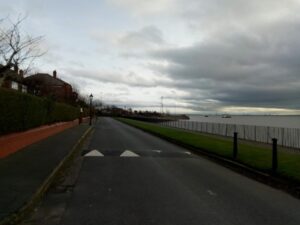
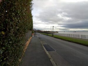
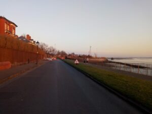
The photographs here are from 2009 (the dates have got jumbled up in transfer at some point) and a couple showing the site of two of the bunkers from December 2017. In the earlier photos Frances & Jules are standing on the rooves of the bunkers so you can see where they are and how hard they are to spot just from a few yards away. My, crouched by the entrance, shows the scale. The later photos show they are even harder to spot now, and I saw the entrances seem to have been filled in more.


These ‘bunkers’ are probably the coastal defence battery as described on Wikipedia (the first sentence quoting the entry on heritage gateway: “Listed as in poor condition (surveyed in 2000) is Coastal Battery S0011771 (Crosby Point Battery), between Coastguard Station and Hightown, north of Crosby. This is near the end of the West Lancs Golf Course, a mile south from Hightown station just off the footpath from Hall Road to Hightown. When Sefton Council upgraded the Sefton Coastal Footpath they blocked up two [actually three] gun emplacements that remained of the Fort Crosby site.” https://en.wikipedia.org/wiki/Hightown,_Merseyside


Ironically these bunkers used to be hidden slightly back in the dunes so one had to look to find them. Now they are exposed near the path but are less visible.


By contrast in Jersey (where they obviously have more unique for Britain war heritage), in Ireland, or in other countries I see more evidence that some sites and remnants are actually preserved and the memory kept.


The World War II remains are listed in the various databases, it seems heritage is preserved quite well digitally, but not in reality. Three World War Two invasion defence pillboxes can be seen near Gorsey Lane and are listed in the database, each as: Type 23 World War II concrete pillbox, constructed in the period 1940 to 1941. These are found in the Defence of Britain Archive of the Council for British Archaeology, 2002.


Each feature is listed on the Heritage Gateway / Pastscape database


Crosby Point Coastal Battery and its history is recorded here:


http://www.pastscape.org.uk/hob.aspx?hob_id=1425941


Clicking on related monuments give you the descriptions of others nearby, though which describe each one I am writing about I am not sure because I don’t know the precise locations.


One pillbox is here: http://www.pastscape.org.uk/hob.aspx?hob_id=1425940


It is a shame that the links to these various really useful and interesting sites are not more obvious on the front page or links of ‘Historic England’, the body formerly known as English Heritage. This page does enable you to search listed and many other heritage sites: https://historicengland.org.uk/listing/the-list/non-listed-sites/


But only of course in England, in our artificially divided island where official heritage maps, like traffic and transport information has to stop at arbitrary lines on a map between Wales, England and Scotland.


A Channel 4 programme, ‘Britain at Low Tide’ featured this section of coast in episode two in November 2016. http://www.channel4.com/programmes/britain-at-low-tide Channel 4 promoted the CITiZAN database and coastal archaeology survey app. https://citizan.org.uk/app/ Created by different partners, it uses a variety of sources including much information from Historic England’s databases. The map is easy to use and you can pull up the results around Hightown including the remnants I am talking about. Unfortunately, the Bing map base is not as useful for the coastal areas as looking at the Ordnance Survey maps that underlay the feature on the Historic England site. And the regular Ordnance Survey map does not show these features.


Note. http://www.heritagegateway.org.uk/gateway/

A search on a typical Hightown postcode set at 2km (to not only cover the built up settlement) brings up many results – quite a few in the historic villages of Ince Blundell and Little Crosby, but most of the entries listed are the sites of ships wrecked off the coast near Formby – there are 50 !! listed over the last 250 years.


I wrote about the same topic on this website, last year, here: https://kironreid.co.uk/2017/07/21/failure-to-preserve-world-war-2-heritage-in-nw-england/

‘Failure to preserve World War 2 heritage in NW England.’ 21 July 2017.

I’ve raised the issue several times since 2008, in 2010, 2011.


On a nearby preserving the past topic I’ve also tried to get local and heritage authorities interested about a small aspect of railways heritage. I’ll write about that next.


Failure to preserve World War 2 heritage in NW England.

Unpublished letter to the Times, August 2015, reflecting concerns about failure to protect localised World War two sites. I had raised this and concern about the failure of Councils and official public heritage bodies to protect other local small scale industrial heritage relics (as monuments) in 2007, 2008, 2010 and 2011 with one effective response from a coastal district archaeological preservation project officer.

Sir,

As much of the country wallows in the World War I nostalgia fest, the visible remains of the fight to save civilisation in World War 2 seem sadly neglected – certainly in the North West. In the Liverpool City region – whether at Crosby / Hightown / Altcar (Sefton district), Wirral, Liverpool, Warrington, West Lancs, the pill boxes and gun emplacements are not so much deliberately run down or neglected but simply unknown and ignored. They are not preserved or enhanced by anyone. I’ve seem similar situations with the reminders in Wales north and south. Notable exceptions being local history signage for key parts played in WW2 at Beaumaris, and along the Wallasey promenade marking ships lost, and popular remembrance of the May 1941 Blitz in Liverpool & Bootle. The pill boxes remain the most visible reminder if you know where to look. Maybe the Government branding change for English Heritage will enable them to assist conserving smaller everyday historic sites from our more recent war time and indeed industrial heritage.

Kiron Reid